Forest Dynamics Plot
Wanang Conservation hosts a 50-ha permanent forest dynamics plot, which is a part of a global network of forest research plots dedicated to the study of tropical and temperate forest function and diversity, managed by the Center for Tropical Forest Science (CTFS).
The Wanang plot (PIs , G. Weiblen, University of Minnesota and V. Novotny, BRC) is one of the most important biodiversity research initiatives in PNG and the largest ecological research facility in the country.
It is important also internationally, as the only CTFS plot east of the important biogeographic divide known as Wallace’s line (there are no CTFS plots in the Indonesian part of New Guinea or Australia). It is attracting overseas and local researchers, with ongoing research on plants, insects and vertebrates, becoming thus a focal point
of PNG’s biodiversity research.
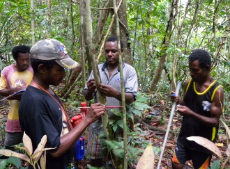
It is a huge undertaking as the plot survey includes tagging, mapping and identification of 288,000 plants, from more than 550 species, mostly done by Wanang and BRC research technicians. The plot spans a forest ridge:
We can plot all individual plants for each of 550 plant species. For instance, ton tree (Pometia pinnata) appears to dislike forest ridges:
We are presently (2016-7) in the middle of the second survey of the plot which should reveal changes in the forest composition during the past five years, including the strongest El Nino drought of the past twenty years, experienced by the forest in 2015.
Photo gallery: Forest Dynamics Plot
This is what happened when we tagged the last of these trees:


